
ESG & Stewardship
Coastal Setbacks: The Line That Halves a Lot
Between the boundary pin and the first buildable metre sits a strip no sales pack draws. Zanzibar's own rule reserves thirty metres of every sand-beach lot to the sea, ten where the edge is cliff, before a forty-five percent coverage cap even applies. The allocator who prices frontage without measuring the setback is pricing a rendering, not a title.
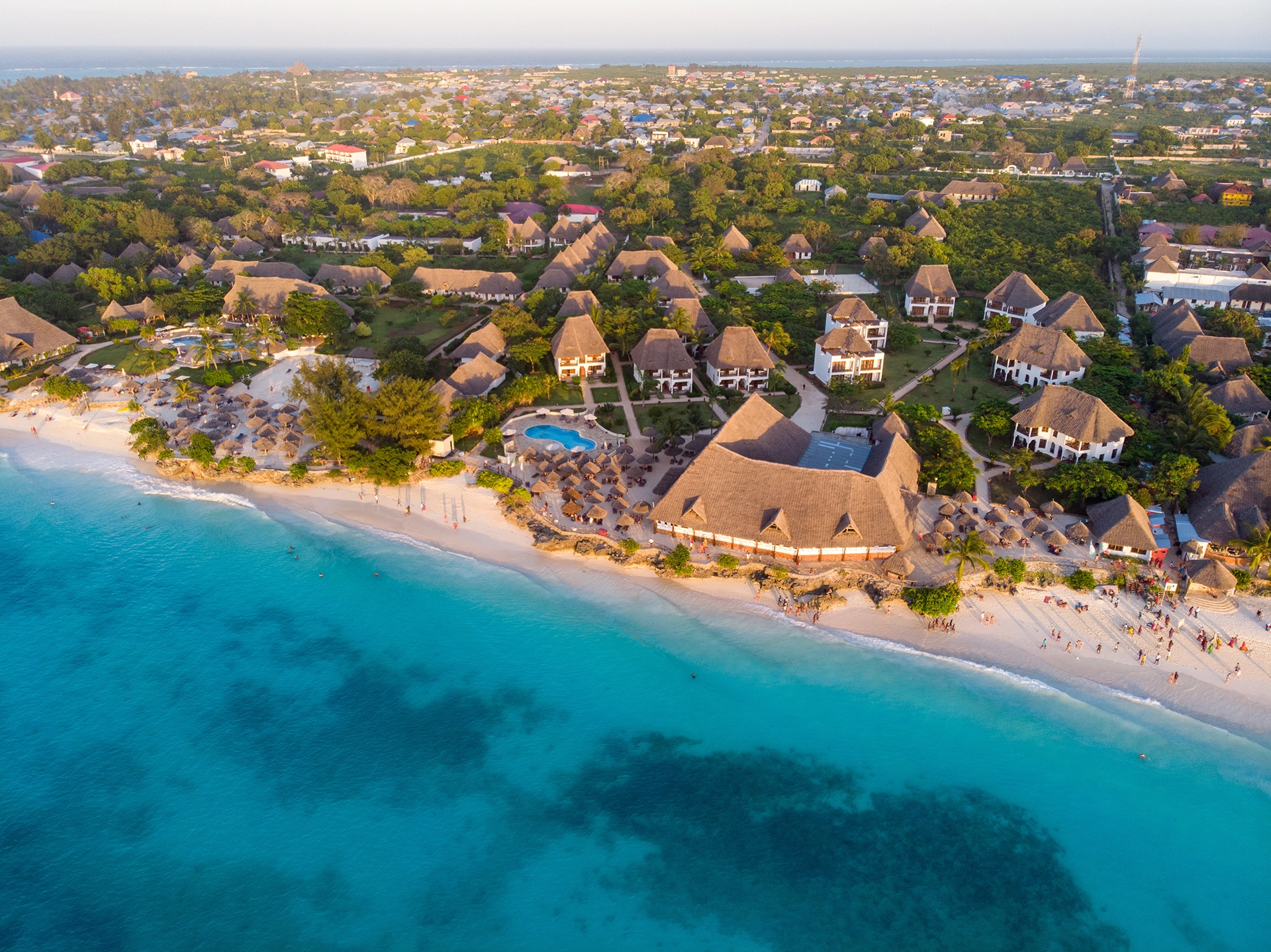
The Gap Nobody Draws
The distance between the boundary pin and the first buildable wall is not a footnote. It is a line drawn by statute, not by the seller, and it removes real square metres from every coastal lot before a single foundation is poured. On Zanzibar's sand beaches the removal is thirty metres, measured from the highest reach of the tide. On a cliff edge it is ten. Neither number appears on a site plan rendered for a buyer presentation.
A setback is enforced at the point of construction, not at the point of sale. Zanzibar's Development Control Unit requires the reserved strip to appear on the topographic map submitted with every building-permit application, marked against the numbered boundary beacons, before the authority reviews a single elevation drawing. The line is a condition of the permit, not a courtesy shown to neighbours.
The number that matters to an allocator is the second number, not the first. A plot quoted by frontage or by hectare is a cadastral figure lifted from the land lease. What survives the setback strip, the side boundaries, and the coverage cap is a smaller, buildable figure, and that second figure is the one an underwriting model should actually price.
Two Lines, Not One
Zanzibar's own rule does not point to a single physical mark. The building-permit guidelines define the reference as "the line of highest High-Water Mark (HWM), top line of the beach, i.e. line of the first vegetation from sea sand, dunes or cliff if any." Two different features are offered as equivalent: the tide's highest documented reach, and the point where stable vegetation begins. On many beaches these lines run close together. On an accreting or eroding shore they do not.
A vegetation line is a living boundary, not a surveyed one. It advances after a season of calm accretion and retreats after a single storm strips the foredune. The highest high-water mark, by contrast, is a tidal datum a surveyor fixes from a documented reading. Regional shoreline-change guidance for the Western Indian Ocean treats the vegetation line, the dune crest, and the high-water mark as three distinct candidate baselines, precisely because a planner has to choose one and accept that the others would have drawn a different strip.
Which line a surveyor picks changes what the buyer can build. A plot where vegetation has crept seaward of the true highest-tide mark gains buildable depth on paper that a storm can take back. A plot surveyed against the tidal datum in a year of heavy accretion may show a generous vegetation line that will not survive the next cyclone season. Neither error is visible in a sales rendering. Both are visible in the underlying survey.
The setback line is not drawn from where the sea is today. It is drawn from where a surveyor found the sea, at a moment someone else chose.
Victaura Research
Zanzibar's Own Number
The Revolutionary Government of Zanzibar sets its coastal setback in the building-permit rules administered by the Development Control Unit, under the Town and Country Planning Act, Cap. 85 of 1955, and the Development Control Regulations of 2015. For a plot with a sand beach at the sea-side boundary, the building line must sit at least thirty metres landward of the highest high-water mark. Where the sea-side boundary is a cliff rather than a beach, the minimum drops to ten metres.
The same rule reaches every other boundary of the plot, coastal or not. Structures must sit at least three metres from any boundary that is not the sea-side line, and at least five metres from any boundary running parallel to a road, a rule the guidelines note applies equally to non-coastal plots. A corner lot fronting both a beach and a road therefore carries two different minimums on two different sides, before either is measured against the plot's actual shape.
A coverage cap compresses the buildable area a second time. Zanzibar's general notes for building permits fix maximum site coverage at forty-five percent of the total plot area, and instruct the applicant to state that coverage with reference to the land lease agreement issued by the ministry responsible for land, not the raw cadastral figure. The setback strip is removed first. The coverage cap is then applied to what is left.
Why a Cliff Loses Less Than a Beach
The ten-metre and thirty-metre figures are not arbitrary; they track two different physical regimes. Regional geomorphological classification of the Western Indian Ocean coast, prepared for the Nairobi Convention, separates "exposed low-lying sandy coasts" from "exposed rocky coasts" as distinct primary coastal types, each with its own susceptibility to physical change. Sand beaches are described as subject to shoreface erosion and accretion. Rock cliffs, except where soft or weathered, are described as resistant.
A sand shoreline moves. A limestone or coral-rag cliff, in most conditions, does not. Zanzibar's coastline sits within a fringing-reef coastal type common across the island's western and southern shores, where beach plains form the low-lying, mobile edge of the fringing-reef platform. A cliff boundary removes the horizontal-migration risk a sand boundary carries, which is the physical logic behind the narrower ten-metre figure, not a discount, but a different hazard being priced.
The classification is decided plot by plot, not island-wide. A single stretch of shoreline can carry both coastal types within a few hundred metres, as the regional geomorphology tables note for parts of the Tanzania mainland and Zanzibar's own reef coasts. Two adjoining lots on the same beach can therefore be assigned different sea-side setbacks if the boundary condition itself differs, one lot ending in sand, the next in an exposed rock shelf.
One Coastline, Two Legal Systems
Zanzibar is not governed by Tanzania mainland's coastal planning instruments, and the two should not be read interchangeably. Zanzibar is semi-autonomous within the United Republic of Tanzania, with its own Town and Country Planning Act and its own Development Control Unit issuing building permits. The thirty-metre and ten-metre figures above come from that Zanzibar-specific framework.
Tanzania's mainland runs a separate and, on paper, more conservative regime. Under the Town and Country Planning (Public Beaches Planning Area) Order of 1991, any land within 250 metres of the shore fronting the Indian Ocean is designated a planning area, and a planning scheme for that area must reserve a strip of no less than sixty metres from the high-water mark exclusively for conservation and strictly water-related activities.
That sixty-metre figure is itself the product of a retreat, not an original design. Tanzania's mainland setback was originally fixed at one hundred metres before being revised downward to sixty metres in 1992, according to the regional shoreline-change report prepared for the Nairobi Convention and WIOMSA. A setback line, in other words, is a policy choice that has already moved once in this region, a fact worth weighing against any assumption that today's minimum is permanent.
The Region Has Never Agreed on a Number
Every coastal jurisdiction bordering the Western Indian Ocean has set its own setback line, and the figures diverge by a factor of ten. Kenya's statutory setback line sits at 37.7 metres from the high-water mark. Mozambique's sits at 100 metres. Zanzibar's own sand-beach minimum, at 30 metres, sits below both of its immediate neighbours' benchmarks, though the comparison is inexact: the underlying statutes were not drafted against a shared methodology.
None of the region's setback lines were derived from a published, plot-specific erosion-rate model. The recommendations from the 2002 Nairobi regional workshop on coastal erosion explicitly called for setback lines to be site-specific, taking geomorphology and sensitivity into account, and noted that in practice the priority in the region has generally been to protect a house, a hotel, or infrastructure, regardless of the implications for adjacent areas. A fixed metric distance is administratively simple. It is not the same instrument as a setback calculated from a measured retreat rate.
| Jurisdiction | Reference line | Minimum setback, sand-beach boundary | Governing instrument |
|---|---|---|---|
| Zanzibar (Unguja & Pemba) | Highest high-water mark / first vegetation line | 30 m (10 m where boundary is cliff) | DCU, Building Permit for Investors, 2018 — under Town and Country Planning Act, Cap. 85 of 1955 |
| Tanzania mainland | High-water mark | 60 m reserve strip (originally 100 m; revised 1992) | Town and Country Planning (Public Beaches Planning Area) Order, 1991 |
| Kenya | High-water mark | 37.7 m | Statutory setback line, cited in UNEP/Nairobi Convention & WIOMSA regional report |
| Mozambique | High-water mark | 100 m | Statutory setback line, cited in UNEP/Nairobi Convention & WIOMSA regional report |
The Line Was Never Fixed to Begin With
A setback measured from a tidal datum assumes that datum holds still. It does not. At Flic-en-Flac on Mauritius's west coast, the documented position of the high-water mark moved eight metres between 1980 and 1994, a measured shift, not a modelled one, recorded in the island's own shoreline monitoring. A fourteen-year retreat of that scale, applied to a thirty-metre statutory setback, would have consumed more than a quarter of the reserved strip before a single permit expired.
A single storm can move the line faster than a decade of gradual change. At Belle Mare, also in Mauritius, the shoreline receded roughly five metres in 1988 as a result of tropical cyclone activity, a one-event retreat comparable in scale to years of ordinary seasonal change. Zanzibar's own coastline carries the same exposure in kind, if not in a quantified rate: regional case records note an erosional regime at Nungwi, on Zanzibar's northern tip, through the early 1990s that later reversed into accretion, without a published survey pinning the magnitude of either phase.
Where a beach has been lost entirely, it has sometimes been engineered back, at a cost the setback line does not account for. At Kunduchi Beach, on the Tanzania mainland north of Dar es Salaam, a hotel that had been reduced to within two metres of the advancing sea recovered thirty to forty metres of beach width through a 1997-98 land reclamation project. The buildable envelope, in that case, was not fixed by the original setback survey. It was restored by capital expenditure the original title never priced in.
A brochure draws the plot. It does not draw the strip the plot is not allowed to use.
Victaura Research
The Arithmetic a Brochure Skips
A setback is a percentage loss before it is a metre figure, and the percentage is largest on the narrowest lots. Consider, illustratively, a beachfront parcel fifty metres deep from the sea-side boundary to its rear line. A thirty-metre sand-beach setback removes sixty percent of that depth before the forty-five percent coverage cap is even applied to what remains. On a parcel one hundred metres deep, the same thirty-metre strip removes thirty percent, half the proportional loss, on a lot merely twice as deep.
Depth, not frontage, is what a coastal setback taxes. A wide, shallow lot loses far more of its buildable area proportionally than a narrow, deep one, because the setback strip runs parallel to the shoreline and its width does not scale with the plot's frontage. Two lots of identical total area, one wide and shallow, one narrow and deep, can carry materially different net buildable footprints once the strip is subtracted, a distinction no per-square-metre asking price captures on its own.
Two lots, same beach, same price per square metre. One gives up sixty percent of its depth to the line. The other gives up thirty. The listing does not say which.
Victaura Research
Adjacent, Not Identical
Two contiguous lots on the same beach can carry different rules on the same day, for reasons visible only in the boundary survey. If one lot's sea-side boundary is classified as sand beach and its neighbour's, a few metres along the same shore, transitions to an exposed rock shelf, the two setbacks diverge, thirty metres against ten, despite an identical asking price per square metre and an identical view.
Corner lots absorb the rule from two directions at once. A plot fronting both the beach and an access road carries the sea-side minimum on one boundary and the five-metre road-parallel minimum on another, with the ordinary three-metre rule applying to whatever boundary remains. The resulting buildable polygon is rarely the simple rectangle a floor plan implies.
The coverage cap then applies to whatever polygon survives the setbacks, not to the original plot. Because Zanzibar's forty-five percent ceiling is calculated against the land-lease area, two lots with identical lease areas but different setback geometries can support different maximum building footprints even before a single design choice is made.
What a Floor Plan Does Not Draw
A rendering shows a building on a green lawn running to the waterline. The statute shows a strip in between that the rendering has simply omitted. Nothing in Zanzibar's building-permit guidelines prohibits landscaping, a pool, or a jetty within the setback area, the optional-drawings section of the same guidelines explicitly contemplates pools and jetties as permitted structures subject to their own architectural and structural review, but it does prohibit the building envelope itself from encroaching on the reserved strip.
Due diligence on a coastal lot, in this framework, is a survey question before it is a design question. Confirming which reference line applies, high-water mark or vegetation line, and which boundary classification governs each side of the plot, determines the net buildable area before an architect draws a single wall. A sales pack built from the gross lease area, without that survey step, is pricing a number the permit process will not honour.
Honestly Disclosed
The comparative setback figures in this piece do not share a common methodology, and that gap is a genuine limitation, not a rounding error. Kenya's, Mozambique's, and Zanzibar's own minimum distances come from different statutes, drafted in different decades, none derived from a published erosion-rate model specific to the plot in question. Comparing them side by side is useful for orientation. It is not the same as comparing outputs of a single, consistent coastal-hazard methodology.
No published, site-specific erosion-rate mapping for Zanzibar's own coastline was located for this piece. The regional shoreline-change literature cited here documents measured retreat and accretion at named sites in Mauritius and on the Tanzania mainland, and records a qualitative erosion-to-accretion reversal at Nungwi, on Zanzibar itself, without a quantified rate. Where the region's dynamic-setback methodologies exist, the erosion-rate multiplier used in parts of the United States, the retreat-based formula used in France, no equivalent published model was found applied to Zanzibar's coastline specifically. That is an absence worth naming, not filling with an estimate.
The 2018 guideline cited throughout this piece is a Development Control Unit publication and, like any administrative rule, is subject to revision. A principal underwriting a specific plot should confirm the current setback and coverage figures directly with the Development Control Unit at the time of application, rather than relying on a figure published in 2018, however consistent it has proven with the regional legal record reviewed here.
What This Means for the Allocator
A coastal setback is not a defect in a title. It is a term of the title, and it prices like one. The allocator who underwrites a Zanzibar coastal plot against its gross lease area, without first establishing which reference line applies to that specific boundary and which classification governs each side, is underwriting a number the permit process was never going to honour.
The buildable envelope, not the plot size, is the asset. Everything in this piece, the reference-line ambiguity, the cliff-versus-beach distinction, the divergence between Zanzibar's own rule and its mainland and regional neighbours, the historical instability of the reference line itself, collapses into a single underwriting instruction: measure the strip before pricing the frontage.
Skin in the game disclosure. Victaura, through its parent Greystone B.V. (Netherlands), holds an active operating position in prime resort property. Readers should assume commentary may be influenced by, or benefit, Greystone's position. This document is classified as marketing material under MiFID II Article 24(3). It is not investment advice.
Key takeaways
- - Zanzibar requires a minimum 30-metre building setback from the highest high-water mark on sand-beach plots, and 10 metres where the sea-side boundary is cliff (Zanzibar Development Control Unit, Building Permit for Investors, 2018).
- - The same Zanzibar rule caps site coverage at 45 percent of total plot area, applied after the setback strip is excluded (Zanzibar DCU, 2018).
- - Zanzibar's reference line is defined as the highest high-water mark or, alternatively, "the line of the first vegetation from sea sand, dunes or cliff", two physical markers that do not always coincide (Zanzibar DCU, 2018).
- - Tanzania's mainland reserves a separate 60-metre public-beach strip from the high-water mark under its own 1991 planning order, a distinct legal regime from Zanzibar's despite the shared coastline type (Town and Country Planning (Public Beaches Planning Area) Order, 1991, cited in UNEP/Nairobi Convention & WIOMSA regional report).
- - Tanzania's mainland setback was originally set at 100 metres before being revised down to 60 metres in 1992, evidence that the line is a policy choice, not a fixed physical fact (UNEP/Nairobi Convention & WIOMSA, Shoreline Changes in the WIO Region).
- - Neighbouring jurisdictions diverge sharply on the same question: Kenya's statutory setback line sits at 37.7 metres from the high-water mark, Mozambique's at 100 metres (UNEP/Nairobi Convention & WIOMSA regional report).
- - At Flic-en-Flac, Mauritius, the measured position of the high-water mark shifted 8 metres between 1980 and 1994, showing the reference line a static setback is drawn from can itself move before a project breaks ground (Jootun et al., 1994, cited in UNEP/Nairobi Convention & WIOMSA regional report).
- - Dar es Salaam's Kunduchi Beach Hotel, on Tanzania's mainland, recovered 30-40 metres of beach width through a 1997/98 land reclamation project after erosion had brought the sea to within 2 metres of the property (UNEP/Nairobi Convention & WIOMSA regional report).
References
- Zanzibar Development Control Unit (DCU), Building Permit for Investors — Drawing Guidelines and Procedures, 2018
- UNEP, Nairobi Convention Secretariat & WIOMSA, Shoreline Changes in the Western Indian Ocean Region
- Kairu, K. and Nyandwi, N. (eds), Guidelines for the Study of Shoreline Change in the Western Indian Ocean Region, IOC Manuals and Guides No. 40, UNESCO, 2000
- Cambers, G., Planning for Coastline Change: Guidelines for Construction Setbacks in the Eastern Caribbean Islands, UNESCO, 1997
- Coastal Wiki, "Setback area"
- North Carolina Department of Environmental Quality, Oceanfront Construction Setback & Erosion Rates
- North Carolina Department of Environmental Quality, What You Should Know About Erosion and Oceanfront Development
- Nairobi Convention, Tanzania Marine and Coastal Resources Governance — Country Profile
- United Republic of Tanzania, Environmental Management Act, Cap. 191 (2004)
- United Republic of Tanzania, Fisheries Act, Laws of Tanzania (principal legislation)
- United Republic of Tanzania, Environmental Management (Integrated Coastal Zone Management) Regulations, 2024
- Inter-American Development Bank, Coastal Setbacks in Latin America and the Caribbean: A Study of Emerging Issues and Trends
- VLIZ, Managing Beach Resources in the Smaller Caribbean Islands
- Springer Nature, "Setbacks", Encyclopedia of Coastal Science
- Ardean Law Chambers, Land for Investment and Doing Business in Zanzibar
- Wikipedia, Fumba Town (Zanzibar seafront masterplan, scale reference)
The information on this website is provided for informational purposes only and does not constitute an offer, solicitation, or financial advice. Indicated returns are estimates and are not guaranteed; past performance is not indicative of future results. Capital invested is at risk.
Considering an allocation to luxury real estate in the locations we operate? Speak to us about our current and upcoming projects.
Speak to Victaura →Related insights
ESG & Stewardship
Environmental Constraints: The Scarcity Premium
Building moratoria, height caps and protected-area statutes are usually read as headwinds. The record across several resort jurisdictions points the other way: a binding, tested limit on new supply becomes a floor under the value of everything already built. The constraint does not eliminate risk — it relocates it from the market to the statute book, and a statute book that has survived a court challenge or a referendum holds longer than most underwriting models assume.
Destinations
Leasehold in Prime Resorts: Pricing a Term-Bound Right
Foreign buyers in prime resort markets rarely buy freehold. In Zanzibar they buy a 99-year leasehold. In Bali they buy an 80-year right of use. A term-bound right is not a title, and it does not price like one. This is how the allocator underwrites the countdown, and where the marketing line quietly fails.

Market Views
Resort Rental Yield: Gross Headline, Net Residue
The advertised gross yield in a prime resort market is a headline. The net yield the owner actually banks is a residue, left after management, platform commissions, staff and a pool split have each taken their layer. And there is a third cost no brochure prices: the high-season nights the owner keeps for themselves. Whoever wants a lifestyle asset and an income asset in one building pays for both, twice.